A Digital Toolbox
Learn how to use a variety of mobile and desktop based technologies to assess, plan, and design trails across the country.
Presented by:
** This event has passed **
September 08, 2022
10:00 AM to 11:30 AM (Pacific Time) {more time zones}
Cost (RECORDING):
FREE for membersNote:
Closed Captioning is available for this webinar.
Learning Credits are available for this webinar.
This webinar is free. Would you consider a donation to support this webinar?
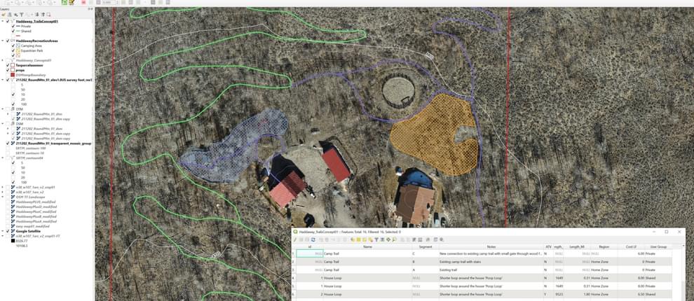
This webinar will provide an overview of how the presenter’s use a variety of technology tools on trail planning projects. The uses range from Data Collection, to Design and Mapping, to Presentation and Sharing, and encompass hardware such as clinometers and GPS units, phone apps, drones imagery and mapping, and a variety of software such as GIS, Adobe products, 3D modeling, and online platforms for sharing the final deliverables created with these tools.
Hugh Duffy Resources

Jon Altschuld, Founder and Principal, Chinook Landscape Architecture, LLC
Centennial, Colorado

Jon Altschuld is Landscape Architect (Colorado and California) with over 12 years of experience. As the founder and principal of Chinook Landscape Architecture, he is experienced in the design of natural areas, trails and open spaces, ecological restoration, parks, streetscapes, and transportation planning, and has an expertise in drone data collection, presentation graphics, 3D visualizations, master planning, and GIS mapping applications. His visualization work has been featured in the ASLA’s sustainable design practices video series and in various news pieces on new construction projects. Jon has taught numerous software workshops and given professional training on SketchUp, Vue, CAD, Lumion, and Adobe Graphics programs within the Planning, Architecture, & Landscape Architecture fields. Jon is currently co-authoring 'Drones in Professional Practice,' an educational and professional book set to be nationally published in late 2020.
Tony Boone, COO, Timberline TrailCraft
Salida, Colorado
Tony Boone is a pioneer in the evolution and art of planning and creating sustainable trails for mountain bikers, hikers, runners, and equestrians, having completed over 400 successful trail projects encompassing fifteen U.S. states and nine countries. His accomplishments include the first official mountain bike patrol in Colorado in 1989, training eight International Mountain Bicycling Association (IMBA) Trail Care Crews (1997-2011), inspiring and conducting mechanized trail dozer training for IMBA Trail Solutions (2001), and contributing to three IMBA books: Trail Solutions: IMBA’s Guide to Building Sweet Singletrack, Managing Mountain Bikes: IMBA’s Guide to Providing Great Riding, and Bike Parks: IMBA’s Guide to New School Trails. During his career, Tony has taught over 3,000 students worldwide the art of sustainable trail design, construction, and management.
Currently, Tony is the owner of Tony Boone Trails and the Business Development Specialist for Timberline Trailcraft. Tony holds a Bachelor’s of Science degree in Animal Science, and a Master of Education focused in Outdoor Adventure Recreation.
We are offering closed captioning for our webinars, thanks to a partnership with VZP Digital. If you are in need of this service, please email us prior to the webinar. An unedited transcript will be sent to all attendees following the webinar.
American Trails is proud to be a certified provider of the following learning credits and continuing education opportunities:
Learning credits are free for attendees for American Trails webinars and the International Trails Symposium, as well as for other conferences, webinars, and workshops we offer credits for. Learn more here.
While we may individually agree (or disagree) in whole or in part with any or all of the participants, the views expressed in these webinars are not necessarily representative of the views of American Trails as an organization or its board and staff. Unless specific situations are noted by presenters, nothing in American Trails webinars should be considered to be interpreted as a standard.
By registering for our webinars, you submit your information to the webinar organizer and associated presenters and sponsors, who may use it to communicate with you regarding this event and their other services. Your organization may also be added to the American Trails Business Directory. You can easily cancel your registration at any time.
5,424 views • posted 06/23/2022